From Wikipedia, the free encyclopedia
Nathia Gali or
Nathiagali (
Pashto:
نتھیا گلی,
Urdu:
نتھیا گلی) is a mountain resort town or hill station in Hazara,
Khyber Pakhtunkhwa,
Pakistan. It is a part of the
Galiaath which are termed such due to several hill-stations in that area ending with the word "gali", most of which are connected to one other. Nathiagali is known for its scenic beauty, hiking tracks and pleasant weather, which is much cooler than the rest of the Galiaath due to it being at a greater altitude. It is situated one hour's drive away from both
Murree and
Abbottabad, it lies midway between the two. Drive time from Islamabad is usually about two hours, unless there is a lot of traffic.
[2]
[edit] Notable visitors
Nathiagali also serves as the holiday home of several prominent Pakistani families. Some of these families have been frequenting the Galiaath for 5 decades and own mountain properties and lodges there. These families tend to socialise together on an annual basis often holding barbecues, bonfires,
games nights, sing-a-longs and trekking parties etc. Some of the more frequent families also give back to the local community, they have helped in renovation of the local church and mosque, and can be seen helping out at the local schools in the summer months. There are several properties leased by multinationals and other organisations as holiday homes for their executives.
[edit] Wildlife
The Nathiagali region serves as home to all kinds of wildlife; various species of birds, insects, butterflies and animals. Unlike the crows of the southern cities of Pakistan, you will find ravens in areas like Nathiagali. Visitors are advised to sun their bedding on arrival to get rid of bed-bugs, and to keep repellants and pesticides for insects as these have a tendency to show up a lot, especially in old homes, and in the monsoon season.
Horses are a common sight during summer months and are offered to children and adults alike for rides at rates that are often negotiable. Monkeys are aplenty, previously known to be a little shy, they have reportedly become more aggressive in recent years, some say this due to increased abuse suffered at the hands of tourists, who often tease these monkeys or try to steal them. Monkeys often come up to guesthouses and hotels in search of
snacks and can be quite noisy and playful.
The World Wildlife Federation has an office in the Galiaath, in recent years, this organisation assisted in the breeding of a certain type of leopard in the
Black Forest right by Dungagali and Nathiagali, this area was thought to be a perfect habitat for such creatures, but according to local reports they frequently come out of the forest to steal cattle of local villagers. One such cat had to be shot. Packs of pie-dogs which were previously considered to be a night-time menace can no longer be seen anywhere in the Galiaath, it is thought that most have been killed and consumed by the newly bred leopards. In the summer of 2006, a large number of women were found dead in the deep valleys of Galiath with wounds showing that they were killed, soon, a large leopard was caught which was believed to be the culprit of all cases, he was kept in captivity but was eventually shot as a result of his aggression, his body has been stuffed and kept in the Dhunga Gali Wildlife Museum, the museum owners named him the Ghost of Galiath. These leopards are rarely spotted. However, a pet dog or animal is very likely to be grabbed by the cats at night, and if any such pets are brought to Nathiagali they must be kept indoors to avoid this.
[edit] History
During
British rule Nathia Gali, then part of Abbottabad tehsil of Hazara District, served as the summer head-quarters of the Chief Commissioner. The town along with
Dunga Gali constituted a
notified area under the Punjab Municipalities Act, 1891. The income in 1903-4 was Rs. 3,000, chiefly derived from a house tax, whilst expenditure was Rs. 1,900.
[2]
[edit] Tourism
Nathia Gali town also serves as the administrative centre of Nathia Gali
Union Council. It is located in
Abbottabad District,
Khyber Pakhtunkhwa. At 2,500 m (8,200 ft), it is a popular tourist resort in the summer months. It is forested with
pine,cedar,oak
walnut and also
oak and maple trees.
During the summer, Nathiagali is relatively popular amongst tourists, but due to its limited size and availability of property, it is not thronged by as many people as the hill-station Murree, which is only an hour away.but nathiagali is to much peaceful and attractive for tourists regardng its beauty as compare to murree.
Accommodations are excellent in Nathiagali; hotels and resorts provide excellent quality accommodations equipped with all facilities. The most popular hotels are Green Retreat, Elites Hotel, Amore Hotel and many other hotels and rest houses. In summer their rates become very high.
[edit] Scenery
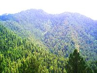
Scenic view of Nathia Gali
The natural scenery is highly magnificent. It is actually famous for it scenic beauty, the lush green meadows, deep forests of oak, cedar and pine, fog in July/August present a glory. In winter snowfall makes scene more attractive and beautiful. The church in Nathi Gali is a remnant from the period of British Government, it is totally made of wood. It is situated at the edge of the mountain from which there is a beautiful sight.
Kashmir can be seen right behind this church, and is a wonderful scene.
Nathi Gali has a mini bazzar. The nearest place to Nathi Gali is Kala Bagh.
Mukshpuri and
Miranjani are two nearby high peaks. Both peaks are highly beautiful and present natural beauty. Taj Mahal hotel is also located in Nathia Gali.
[edit] Subdivisions

Administrative subdivisions of Nathia Gali.
The Union Council of Nathia Gali is divided into the following areas: Bagan, Donga Gali, Jhansa, Keri Sarafali, Keri Raiki, Lassan, Malach, Nathiagali and Pasala.
[1]
[edit] Ethnic groups
The main tribe of Nathia Gali are the
Karlals, also known as Sardars. Many Sardars can be found serving at the National Level, like Justice Sardar Raza Khan, Sardar Mohmmad Yaqoob, Sardar Haider Zaman, Sardar Sajjad Ahmed Khan of Makol Payeen candidate of PF-48, Sardar Mushtaq Ahmed who served as DOR and contested election on PPP ticket and Sardar Ahmad Nawaz Bagan (President Hazara Student Council).
[edit] See also
[edit] References
[edit] External links
[edit] Gallery
Coordinates:  34°04′N 73°23′E / 34.067°N 73.383°E / 34.067; 73.383


 Mukeshpuri mountain and Ayubia National Park.
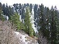 Conifer forests on the mountain.
 Road to Nathiagali and Ayubia National Park.


